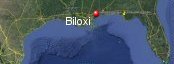
Biloxi, Mississippi's History with Tropical Systems
(br) = Brush (ts) = Tropical Storm (bd) = Back Door, meaning coming from over land from opposite coast.
Not all names are noted. Also, storms before 1950 were not named. Not every stat on every storm description is given. (since 1871)

Years within or near core
1872ts
1877br
1879ts
1881ts
1885ts
1887-2ts
1889ts
1892ts
1893tsbr
1893
1894tsbr
1895ts
1900ts
1901
1906
1907ts
1911ts
1912
1914bdts
1915tsbr
1916
1917brm
1923-2ts
1926
1932
1932bdts
1947
1948tsbr
1950br
1955-2ts
1956br
1960 (HURDAT)
1964xtropstbd
1965brm
1969m
1979m
1985m
1985tsbr
1995brm
1998
2001bdsubts
2002-2ts
2003tsbr
2004m
2005bdts
2005m
2009ts
2011tsbr
2017ts
2017
2018ts
2020ts
2020-2br
2021ts
2021mbr
2024bdtsbr
61 times in 153 years (as of end of 2024)


Names from list above (C storms most likely to impact the area)
Baker
Brenda
Flossy
Hilda
Ethel
Betsy
Camille
Frederic
Juan
Elena
Opal
Georges
Allison
Hanna
Isidore
Bill
Ivan
Cindy
Katrina
Ida
Lee
Cindy
Nate
Gordon
Cristobal
Sally
Zeta
Claudette
Ida
Francine
Brenda
Flossy
Hilda
Ethel
Betsy
Camille
Frederic
Juan
Elena
Opal
Georges
Allison
Hanna
Isidore
Bill
Ivan
Cindy
Katrina
Ida
Lee
Cindy
Nate
Gordon
Cristobal
Sally
Zeta
Claudette
Ida
Francine
Tropical Storm to Hurricane ratio
TS = 36, 59.02%H = 25, 40.98%

Longest gap between storms
14 years 1933-1946How often this area gets affected?
Brushed or hit every 2.51 yearsAverage years between direct hurricane hits. (hurricane force winds for a few hours)
Once every 9.56 years. (16 hits) State statsAverage years between direct major hurricane hits. (major hurricane in advisory upon passage)
Once every 38.25 years. (4 hits)Average MPH of hurricane hits. (based on sustained winds from advisories, not gusts)
102 mphStatistically when this area should be affected next
Before the end of 2027
This is just a statistical average & does not mean the area will be affected by that year.
Last affected by
2024 September 12th Tropical Storm Francine brushes well to the west by 68 miles while moving north-northeast with 50 mph winds.This area's hurricane history
- 1893 October 2nd 110 mph from the southwest, logs from Handsboro mills battered down the Biloxi Bay railroad bridge. Shorelines crumbled; boat crews drowned. Corpses continued to surface a month later. About 2,000 died; 100 of them were Mississippians.
- 1901 August 15th 80 mph category 1 from the south-southwest.
- 1906 a hurricane just east causes a high storm surge September 27th with 110 mph winds causes very heavy damage, pressure 28.29 from the south-southeast
- 1912 September 14th 75 mph from the south
- 1916 July 5th 90 mph from the south-southeast batters area for 16hrs causes heavy damage & kills 10, many flipped over in cars trying to escapethe 115 to 120 mph winds. 11.6 foot storm surge
- 1926 September 21st 75 mph weakening to tropical storm hits. Northern part of eye passed over Biloxi at 9:00 am pressure 29.03 inHg from the east-southeast
- 1932 September 1st 80 mph from the southeast
- 1947 September 19th, 90 mph from the east-southeast a storm surge of 11.1 feet well to southwest kills 22 on Gulf coast. Newspaper article
- 1960 September 15th a cat one with 80 mph winds (HURDAT) weakens while moving in
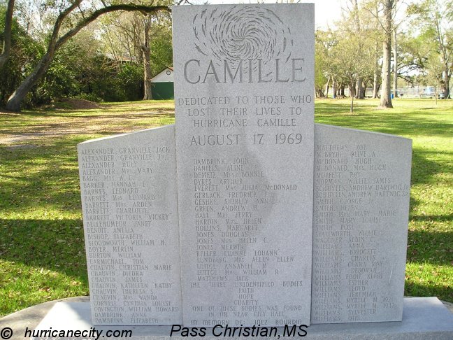
- 1969 camille a category 5 165 mph from the south-southeast total devastation storm surge 19.52 feet in Biloxi 1.4 billion dollars damage August 17th hurricane camille just west of here winds here reported at 130 mph. Damage photo | Monument | monument | Surge reports | Advisory showing winds & size before landfall | Camille headlines from New York | Camille remembered newspaper 20 yrs later | Newspaper headline | Surge animation | Reanalysis of Camille | USGS surge info.
- 1979 September 13th, Hurricane Frederic hits just east with 130 mph winds from the south-southeast. NHC Wallet
- 1985 Elena changed direction 3 times, finally hit with 115 mph winds Labor Day, 1 to 2 billion in damage. Biloxi in morning on September 2nd had sustained winds of 92 mph, peak gust 115 mph. (from Civil Defense) Biloxi (west) had over the road debris at 8 feet at Route 90 - oceanside. Biloxi debris line height above mean sea level was 10.5 feet at Route 90 - east bridge. Michael Laca in eye | Wind map | Newspaper headlines | Average model error | Damage survey
- 1998 September 28th, Hurricane Georges west eyewall over area with 105 mph winds causing moderate damage from the southeast. USGS surge info
- 2004 September 16th Hurricane Ivan passes to the east with 130 mph winds from the south. | Radar animation (Brian McNoldy, Univ. of Miami, Rosenstiel School) NHC Report
- 2005 August 29th Hurricane Katrina hits well west of here with 105 mph winds closest approach at landfall from the south.Biloxi-keesler afb sustained 110/47 kt 1355 utc peak 110/78 kt 1355 utc. 5,000 homes & businesses destroyed. A category 5 surge in biloxi river at wortham 26.00 ft accompanies this hurricane & kills well over 100 in this area. Radar animation | Newspaper article about winds | Waterline Camille vr Katrina | Newspaper damage map | Jim Williams from HurricaneCity.com predicts a hurricane hit for this area on June 1st 2005. | Damage shot | Our coverage as it happened | Damage shot | Camille monument damaged by Katrina | Damage shot | Katrina memorial | Katrina memorial panned out | Katrina memorial closeup | Camille surge pole in Pass Christian destroyed by Katrina | Illinois newspaper 9 months later | Color enhanced satellite vapor image | Track and dates | Surge animation | USGS surge info
- 2017 October 8th Hurricane Nate center passes over with 85 mph winds 984 mb while moving quickly North.Biloxi gust to 71 mph storm tide nearly 11 ft. USGS surge info | Power outage map | NHC report
Please keep these stats free. Donate to HurricaneCity.
.gif)
Stat sources:
Text Sources:
- "Divine Wind" by Kerry Emanuel
- "Florida Hurricanes and Tropical Storms" by John M. Williams and Iver W. Duedall
- "Florida's Hurricane History" by Jay Barnes
- "Hurricane Almanac" by Bryan Norcross
- HurricaneCity.com calculations by Jim Williams
- "Hurricanes and the Middle Atlantic States" by Rick Schwartz
- "Hurricane Watch" by Dr. Bob Sheets and Jack Williams
- "Inside the Hurricane" by Pete Davies
- "Isaac's Storm" by Erik Larson
- "Killer 'Cane" by Robert Mykle
- "Lunatic Wind" by William Price Fox
- Miami Herald newspaper (microfilm)
- "Path of Destruction" by John McQuaid and Mark Schleifstein
- Sun Sentinel newspaper (microfilm)
- "The Major Hurricanes To Affect The Bahamas" by Wayne Neely
- "The Ship and the Storm" by Jim Carrier
- Plus many more......