
Fort Lauderdale, Florida's History with Tropical Systems
(br) = Brush (ts) = Tropical Storm (bd) = Back Door, meaning coming from over land from opposite coast.
Not all names are noted. Also, storms before 1950 were not named. Not every stat on every storm description is given. (since 1871)

Years within or near core
1871m
1871br
1876tsbr
1876bdbr
1878
1885br
1888
1888-2ts
1889bdts
1891br
1891bdts
1892bdts
1901ts
1903
1904ts
1906bd
1906m
1909brm
1909-2ts
1916ts
1924bdts
1926
1926m
1926
1928
1928m
1929brm
1932tsbr
1933m
1933br
1935-2brm
1935
1941m
1945m
1946ts
1947m
1947bd
1948
1948bdbrm
1949m
1950m
----1952-53tsbd
1956ts (HURDAT)
1960brm
1964
1964bdm
1965brm
1974subts
1976ts
1979br
1981-84ts
1992brm
1995tsbr
1998br
1998bdts
1999ts
1999
2005
2005bd
2006ts
2010tsbr
2016brm
2017bdbrm
2020tsbr
2022mbdbr
2022br
2024mbr
2024bdbr
73 times in 153 years (as of end of 2024)


Names from list above (I storms most likely to impact the area)
King
Donna
Cleo
Isbell
Betsy
Dottie
David
Dennis
Isadore
Andrew
Jerry
Georges
Mitch
Harvey
Irene
Katrina
Wilma
Ernesto
Bonnie
Matthew
Irma
Eta
Ian
Nicole
Helene
Milton
Donna
Cleo
Isbell
Betsy
Dottie
David
Dennis
Isadore
Andrew
Jerry
Georges
Mitch
Harvey
Irene
Katrina
Wilma
Ernesto
Bonnie
Matthew
Irma
Eta
Ian
Nicole
Helene
Milton
Tropical Storm to Hurricane ratio
TS = 26, 35.62%H = 47, 64.38%

Longest gap between storms
8years 1893-1900 & 1966-1973How often this area gets affected?
Brushed or hit every 2.10 yearsAverage years between direct hurricane hits. (hurricane force winds for at least a few hours)
Once every 6.12 years. (25 hits) State statsAverage years between major hurricane hits. (part of eyewall hitting)
Once every 13.91 years. (11 hits)Average MPH of hurricane hits. (based on sustained winds from advisories, not gusts)
108 mphStatistically when this area should be affected next
Before the end of 2026
This is just a statistical average & does not mean the area will be affected by that year.
Last affected by
2024 October 10th Hurricane Milton brushes well to the north by 131 miles at closest approach while moving east-northeast with 95 mph winds.This area's hurricane history
- 1871 August 16th, 115 mph from the east just north, hit map
- 1878 October 21st 80 mph just east from the south-southwest
- 1888 August 16th 125 mph winds from the east-southeast just south. Hit map
- 1903 September 11th a category 1 85 mph from the east-southeast
- 1906 June 17th a category 1 85 mph from the southwest
- 1906 October 18th 115 mph from the south-southwest
- 1926 July 27th, 105 mph from the southeast just east
- 1926 September 18th a large hurricane in miami with 130 mph winds causes a 13ft storm surge here 3,500 structures here destroyed & 26 killed. The Daily news (former sun -sentinel)newspaper didnt publish for 2 days & when it resumed did it from the Lake worth Press. Newspaper headline
- 1926 October 21st 110 mph from the southwest just east
- 1928 August 7th 95 mph winds from the southeast just northeast of here.
- 1928 September 16th, 150 mph from the east-southeast just northeast of here.
- 1933 September 4th 130 mph just north from the east-southeast
- 1935 November 4th yankee hurricane from the northeast hits just south with 75 mph winds 8 ft tides here
- 1941 October 6th, 120 mph to the south from the east-southeast
- 1945 September 16, 30 miles to south & West 130 mph winds causes moderate damage here
- 1947 A major hurricane to north causes heavy damage here September 17th, 130 mph (HURDAT) Hillsboro light reported a winds gust of 155 mph, 121 mph sustained for 5 minutes pressure 27.97 this was a large slow moving storm moving at 10 mph, pounded the area for many hours.An 11 ft storm surge was reported with the New River overflowing it's banks. Suprisingly only 17 killed in florida weather map | Headlines
- 1947 October 12 85 mph from the southwest gusts to 92 mph, this was cloud seeded prior to landfall. Rainfall reported 12 inches in 30 minutes led to creation of the South Florida water management district.
- 1948 September 22nd from the south 95 mph winds
- 1949 just north August 26th, 150 mph from the southeast, gusts to 130 mph here. Weather map | Newspaper headline
- 1950 Hurricane King October 17th 120 mph winds (HURDAT) causes heavy damage especially inland as this small hurricane traveled inland over a small area causing moderate to heavy damage. Track
- 1964 Hurricane Cleo August 27th 95 mph causes a 5 foot storm surge but overall minor damage. Evidence of a Tornado in Davie 1/4 mile wide Broward County $89,000,000 damage. Short period of calm reported in northwest Fort Lauderdale. Fort Lauderdale News does not print for the only time in history. Cars parked on the beach had paint sandblasted off of their sides. Newspaper article photo | NHC Wallet
- 1964 October 14th Hurricane Isbell just north from the southwest with 120 mph winds causes moderate damage here. NHC Wallet
- 1999 October 15th Hurricane Irene hits just west with 75 mph winds pressure 29.18.In weston 4 killed standing in water with electrical line near. Cooper City 1 boy killed standing in water with electric line. Fort Lauderdale Beach water spout hits Elbo Room bar breaking windows 6 sent to hospital with cuts, flips 2 cars outside. Nearby roof blown off, 1 home in broward reports roof blown off. Coral Springs 1 man killed in truck found in canal. Newspaper article | News coverage
- 2005, August 25th, Hurricane Katrina moves towards Dade County moving 20 miles to the southeast while moving west-southwest with 80 mph winds.Many trees blown down, 82 mph gust in Fort Lauderdale. Radar animation (Brian McNoldy, Univ. of Miami, Rosenstiel School) Track and dates | Our live coverage
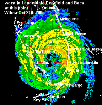
- 2005, October 24th Hurricane Wilma hits from the southwest with 105 mph winds while moving quickly northeast. Wilma passed just northwest of Fort Lauderdale while the east eyewall hit the metro areas. Damage was extensive in downtown ft laud as many glass windows blew out of buildings. Significant roof damage to many buildings, power poles & signs. In Coconut Creek estimated 37 homes left uninhabitable, Cooper City 2. In Coral Springs 93 multifamily dwellings affecting 197 units unihabitable. Dania 109 and Davie 855 unihabitable. In Fort Lauderdale 115 have major damage. Official NHC report has 87 mph sustained with gusts to 104 mph in Weston. Fort Lauderdale NHC final 71 mph sustained winds with gusts to 96 mph. Over 1,000 intersection's traffic lights knocked out in Broward County. Hurricane Wilma caused an estimated 20 billion in damage with 35 deaths in Florida. Radar animation Wilma approaching from southwest (courtesy of hometownweather.com) | Radar animation Wilma leaving east coast (courtesy of hometownweather.com) | Hurricane warning show | Radar still during worst weather | Wilma satelite picture while a category 5 in Caribbean | Mobile home destroyed in Fort Lauderdale | Mobile home heavily damaged in Fort Lauderdale | Newspaper unsafe structure maps | NHC final report
Please keep these stats free. Donate to HurricaneCity.
.gif)
Stat sources:
Text Sources:
- "Divine Wind" by Kerry Emanuel
- "Florida Hurricanes and Tropical Storms" by John M. Williams and Iver W. Duedall
- "Florida's Hurricane History" by Jay Barnes
- "Hurricane Almanac" by Bryan Norcross
- HurricaneCity.com calculations by Jim Williams
- "Hurricanes and the Middle Atlantic States" by Rick Schwartz
- "Hurricane Watch" by Dr. Bob Sheets and Jack Williams
- "Inside the Hurricane" by Pete Davies
- "Isaac's Storm" by Erik Larson
- "Killer 'Cane" by Robert Mykle
- "Lunatic Wind" by William Price Fox
- Miami Herald newspaper (microfilm)
- "Path of Destruction" by John McQuaid and Mark Schleifstein
- Sun Sentinel newspaper (microfilm)
- "The Major Hurricanes To Affect The Bahamas" by Wayne Neely
- "The Ship and the Storm" by Jim Carrier
- Plus many more......