
New York City, New York's History with Tropical Systems

(br) = Brush (ts) = Tropical Storm (bd) = Back Door, meaning coming from over land from opposite coast.
Not all names are noted. Also, storms before 1950 were not named. Not every stat on every storm description is given. (since 1871)

Years near or within core winds
1872bdts
1874bdts
1877bdxtsbr
1878bdbr
1879br
1888bdts
1888br
1893
1893bdts
1894br
1896br
1897tsbr
1903tsbr
1904xhbr
1916br
1924br
1934tsbr
1936br
1938
1944br
1954-2brm
1955bdts
1958br
1960bdts
1960
1961br
1971ts
1972ts
1976
1985
1996bdts
1999ts
2008tsbr
2011
2012
2020ts
2020bdts
1874bdts
1877bdxtsbr
1878bdbr
1879br
1888bdts
1888br
1893
1893bdts
1894br
1896br
1897tsbr
1903tsbr
1904xhbr
1916br
1924br
1934tsbr
1936br
1938
1944br
1954-2brm
1955bdts
1958br
1960bdts
1960
1961br
1971ts
1972ts
1976
1985
1996bdts
1999ts
2008tsbr
2011
2012
2020ts
2020bdts
38 times in 153 years (as of end of 2024)


Names from list above (D storms most likely to impact the area)
Carol
Edna
Diane
Daisy
Brenda
Donna
Esther
Doria
Agnes
Belle
Gloria
Bertha
Floyd
Hanna
Irene
Sandy
Fay
Isaias
Edna
Diane
Daisy
Brenda
Donna
Esther
Doria
Agnes
Belle
Gloria
Bertha
Floyd
Hanna
Irene
Sandy
Fay
Isaias
Tropical Storm to Hurricane ratio
TS = 17, 44.74%H = 21, 55.26%

Longest gap between storms
11 years 1905-1915How often this area gets affected?
Brushed or hit every 4.03 yearsAverage years between direct hurricane hits. (hurricane force winds for at least a few hours)
Once every 13.91 years. (11 hits) State statsAverage years between direct major hurricane hits. (major hurricane while passing by)
Once every 38.25 years. (4 hits)Average MPH of hurricane hits. (based on sustained winds from advisories, not gusts)
90 mphStatistically when this area should be affected next
Due in 2025Last affected by
2020 August 4th Tropical Storm Isaias comes from the south passing just west by 51 miles with 65 mph winds.This area's hurricane history
- 1893 August 24th 85 mph hits N.Y city from the south causing heavy damage. It was traveling 30-36 mph as it passed along this portion of the coast.30ft waves pushed boats well inland winds 80 to 90 mph. Eye passed just east with city under western eyewall.Pressure 29.11 extensive damage on Coney Island. Many trees down in central park & many birds left dead. Point pleasant boardwalk demolished.
- 1916 July 21st, 85 mph to the east clips eastern Long Island from the south-southwest
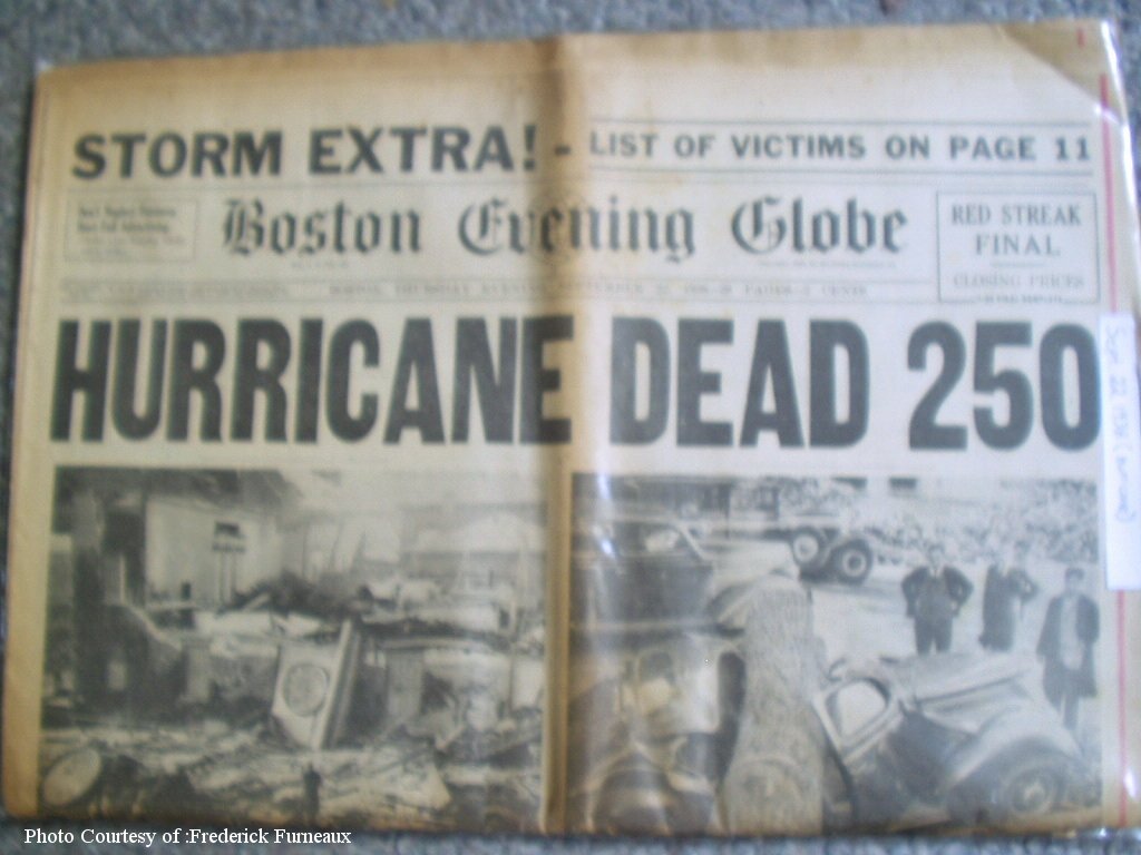
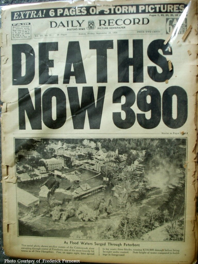
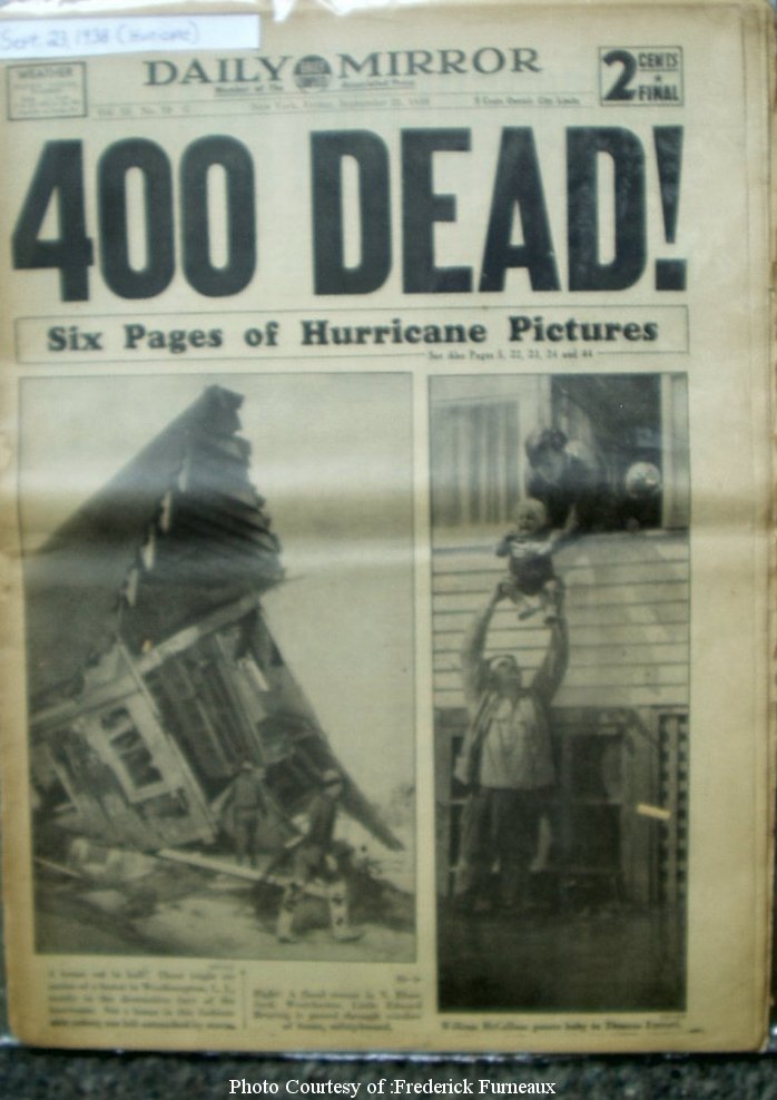
- 1938 115 mph (HURDAT), September 21st, passes 47 miles east of city caused storm surge flooding 3 miles inland as a category 3 in central & eastern Long Island. Reports of a 40 foot wall of water destroyed approximately 14,000 homes, however post analysis by NOAA's Hurricane Research Division (HRD) indicates 10 to 12 feet excluding wave breaks with New York City area 4 to 8 feet. 50 killed on Long Island with over 500 killed in states further north. In Westhampton 150 beach homes were destroyed. In New York City, Empire State Building swayed as much as 4 inches with gusts to 100 mph, but the strongest winds were well east of here. Pressure at Bellport 27.76 inHg. Many warnings were put up too late. This system was moving at a forward speed of 40 mph when it hit. | Newspaper article #1 | #2 | #3 | #4 | Maximum wind map | Monument | Newspaper article southbridge evening news | Best track data | More on the long island express here | Surge animation
- 1944 110 mph hits central long island from the south-southwest on September 15th early morning just a shade west of where the 1938 system came ashore with Minor damage reported weather map
- 1954 September 11th, Hurricane Edna pases just east of the east tip of Long Island with 95 mph winds
- 1960 September 12th Donna hits central long island 65 miles east of New York City from the south-southwest with 100 mph gusts to 125 mph, sustained at 100 mph on eastern end Newpaper Headline | Weather map | More here
- 1976 Belle hits August 10th 32 miles east of New York City peak gust 95 mph system was weakening 24 hrs prior to landfall with a forward speed of up to 25 mph. 75 mph and a 4.5ftstorm surge in battery park. Weather map
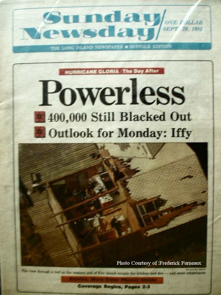
- 1985 September 27th, Hurricane Gloria hits as a cat one 28 miles east of New York City with 85 mph winds but fast forward speed gives area gusts to 115 mph shuts down New York Stock Exchange (NYSE) area reported many pre mature births due to low pressure.Being low tide at landfall may have saved many lives. (moderate damage) Newspaper article #1 | #2 | #3 | #4 | #5 | More on Hurricane Gloria here
- 1991 August 19th Hurricane Bob clips the east end of Long Island with 95 mph winds Bob also dumped heavy rain as area northeast of here suffered the worst damage up to 1.5 billion dollars in damage killing 18, More on Hurricane Bob here
- 2011 August 28th, Irene impacts New York City with as a category 1 with 75 mph while weakening to 65 mph causing minor coastal flooding but alot of power outages.New Yorks Central park had wettest month on record with 18.95 inches of rain. High wind gust at LaGuardia Airport 67 mph with high storm surge point of 4.50 ft at The Battery in New York but averaging 3 to 6 feet on Long Island. Radar animation (Brian McNoldy, Univ. of Miami, Rosenstiel School) Hurricane Warning Show | Irene Suffolk county flooding video | Irene model history | USGS surge info
- 2012 October 29th very large Hurricane Sandy hits while becoming post tropical with winds around 80 mph approximately 100 miles to the south. Great Gull Island, New York, between Long Island and Fishers Island, measured a 1-min mean wind of 65 kt at an elevation of 18 m at 2035 UTC 29 October. The strongest observed peak wind gust (83 kt) from a reliable station was measured at Eaton's Neck by a WeatherFlow site at 24 meter elevation along the northern shore of Long Island, at 2210 UTC 29 October. Area hit very hard especially from storm surge with worst damage on Staten Island where 48 in New York were killed as of November 3rd. Estimates are that Sandy will be a 50 billion dollar disaster second only behind Hurricane Katrina. Seven subways flooded in New York, report surge up to 14 feet in some locations. 8 million without power at one point. Breezy Point neighborhood of Queens, New York, more than 100 homes were destroyed in a fire during and after Hurricane. Bellevue Hospital in Manhattan evacuated its 700 patients because the pumps that supply oil to the generators are in the basement under 8 feet of water. Around 100,000 homes on Long Island were severely damaged or destroyed, primarily by storm surge and waves, with more than 2,000 homes deemed uninhabitable. Islip reported gust to 88 mph, New York-Kennedy gust to 84 mph, New York-Laguardia 74 mph, Long Beach 82 mph, Staten Island P.S. 32 The Giffords School 74 mph, Breezy Point - Queens 78 mph, Kings Point storm surge 12.65 feet Radar animation (Brian McNoldy, Univ. of Miami, Rosenstiel School) Complete stats & images on Sandy | Sandy model history | Sandy best models | Sandy visible satellite movie | Long Island tree damage | Long Isl flooding | Hurricane warning show | PBS documentary Hurricane Sandy | Long Beach, Long Island 19 days after Sandy | Telethon to raise funds | Post NHC | USGS surge info | Details from Lindenhurst
Please keep these stats free. Donate to HurricaneCity.
.gif)
Stat sources:
Text Sources:
- "Divine Wind" by Kerry Emanuel
- "Florida Hurricanes and Tropical Storms" by John M. Williams and Iver W. Duedall
- "Florida's Hurricane History" by Jay Barnes
- "Hurricane Almanac" by Bryan Norcross
- HurricaneCity.com calculations by Jim Williams
- "Hurricanes and the Middle Atlantic States" by Rick Schwartz
- "Hurricane Watch" by Dr. Bob Sheets and Jack Williams
- "Inside the Hurricane" by Pete Davies
- "Isaac's Storm" by Erik Larson
- "Killer 'Cane" by Robert Mykle
- "Lunatic Wind" by William Price Fox
- Miami Herald newspaper (microfilm)
- "Path of Destruction" by John McQuaid and Mark Schleifstein
- Sun Sentinel newspaper (microfilm)
- "The Major Hurricanes To Affect The Bahamas" by Wayne Neely
- "The Ship and the Storm" by Jim Carrier
- Plus many more......