2021 hurricane season landfall predictions

After a very active 2020 Atlantic hurricane season I see no reason that we should not see another very active season. I am calling for 20 to 24 named storms but not as many named storms impacting the U.S mainland coast as last year. My predictions for 2020 called for 18 to 20 named storms & we ended up with 30 but as far as landfall projections once again all of my top 5 were impacted. As I say every year

A city or island could be hit very hard that I do not predict, everyone in the basin should be prepared as if you are in my top 5.

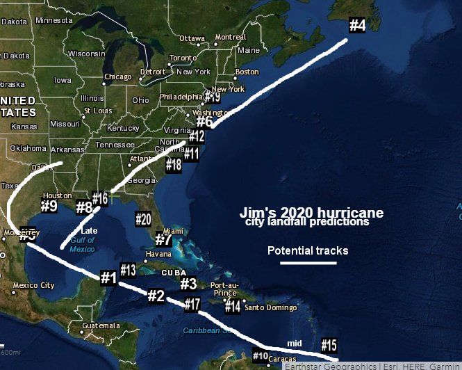
In 2020 we saw several hurricanes impact Louisiana with late season Zeta hitting my #8 Grand Isle, LA as a major hurricane. My number 1 pick for 2020 was Cancun, Mexico impacted by Cristobal, Gamma, Delta & Zeta with 4 impacts I guess you could say that was pretty accurate.

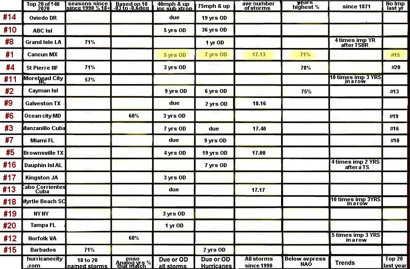
So before each season usually starting in April I create this chart to place my top 20 locations. My top 20 are chosen from my list of 139 cities & Islands in the hurricanecity database. The top 20 are chosen based on being statistically due or overdue for a named storm. Other locations are chosen based on historically being hit in my chosen ENSO Analog years or based on trends.

Predictions chart

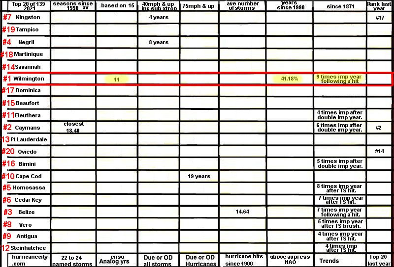
Now once the top 20 are graphed the pecking order is based on the number of columns each location wins based on the 8 criteria at the top. As you can see Wilmington, NC won the most with 3 highlighted boxes in yellow. One of the most important criteria columns is the NAO (North Atlantic Oscillation). Each year I keep track of the NAO in each hurricane season & mark it as either positive or negative at the NCDC NOAA site that keeps track which can be subjective considering some seasons can be half & half. The winner in that category was Wilmington with 41% of all hurricane seasons that they were impacted when there was a positive NAO which which will show up more than negative will this season. That was the highest percentage of all the cities in the top 20 that was calculated. To keep this post as short as possible I cannot get into the specifics on what the NAO can do to hurricane season but in a nut shell a positive NAO can lead to more ridging in the north Atlantic & less troughing.

Another important column on the chart above is what city got hit most in the past ENSO years that I think most closely match up going into this hurricane season. My ENSO analog years are based on being around Neutral at the height of the season plus matching what has happened the past several months. My matching years are 1956-1971-1974-1984-1985-1989-1995-1996-2001-2006-2008-2011-2012-2018-2020 a total of 11 used.

The other cities that did not win any columns were ranked based on whoever has the highest average number of named storms when they get impacted. Based on my prediction of 22 plus named storm the higher the average the higher that city or island is ranked. The method to this madness is more than simply making a circle on a map especially a large one like many do. If you draw a circle from the Carolinas to Maine that means like 80 million are left wondering so I like to narrow it down. So without further ado here is my top 20 for the 2021 Atlantic hurricane season.

#1) Wilmington, North Carolina
#2) Cayman Islands
#3) Belize
#4) Negril, Jamaica
#5) Homosassa, Florida
#6) Cedar Key, Florida
#7) Kingston, Jamaica
#8) Vero Beach, Florida
#9) Antigua
#10) Cape Cod, Massachusetts
#11) Eleuthera Island, Bahamas
#12) Steinhatchee, Florida
#13) Fort Lauderdale, Florida
#14) Savannah, Georgia
#15) Beaufort, South Carolina
#16) Bimini, Bahamas
#17) Dominica
#18) Martinique
#19) Tampico, Mexico
#20) Oviedo, Dominican Republic

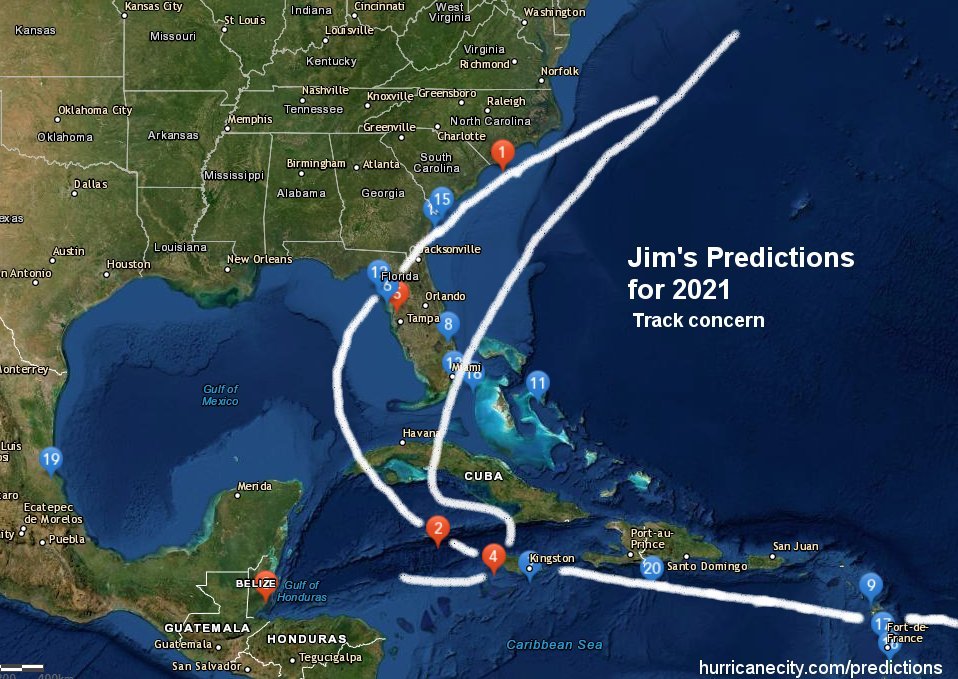
As always I like to pick a track I think may happen and a few times my tracks have been almost identical to what ended up happening. For this year I have a real concern for the big bend, Florida area with a track across from the Gulf in to the Atlantic. Of course this will not be the only track & probably not the only impacts to land. All quadrants of the Atlantic basin will be in play it’s just that I feel this particular track could be big trouble.

Prediction track map

Any way that wraps it up thank you all again for the donations make your plans now and good luck this hurricane season.

hurricane season 2020 landfall predictions

By : Jim Williams May 18th,2020

As we approach another hurricane season all indications are that it will be a busy one. I am predicting between 18 and 20 named storms in the Atlantic basin. My city landfall predictions are based on calculations of 8 criteria mainly statistical with a couple of environmental such as ENSO analog years & the North Atlantic Oscillation. Below is a chart that I use every year before the season starts to calculate my top 20. I arrive at my top 20 cities & islands by using my eight criteria against every city in the database (140) with the areas making the cut by at least being in one of the boxes below.

As you can see the highlighted yellow boxes indicates #1 Cancun, Mexico has data in the most columns (5) of 8 and therefore wins. Then the real calculations begin for example 3 locations share 4 columns and those 3 have order determined by highest % in each column . Here is the list of what areas have the most columns 5)Cancun, Mexico (alone) 4)St Pierre,NF — Cayman Isl, — Manzanillo, Cuba . 3) Grand Isle,LA — Galveston,TX–Ocean city,MD — Miami,FL — Brownsville,TX 2) Oviedo,DR — ABC Isl –Morehead city,NC — Dauphin Isl,AL — Cabo Corrientes,CU — Norfolk,VA & Barbados 1) Kingston,JA –Myrtle bch,SC — NY,NY — Tampa,FL. Each grouping competes for highest % in each column for pecking order. Based on all my number crunching here is my top 20 #1) most vulnerable to #20)moderate.

#1) Cancun, Mexico
#2) Cayman Islands
#3) Manzanillo, Cuba
#4) St Pierre, Newfoundland
#5) Brownsville, Texas
#6) Ocean City, Maryland
#7) Miami, Florida
#8) Grand Isle, Louisiana
#9) Galveston, Texas
#10) Aruba, Bonaire, Curacao
#11) Morehead City, North Carolina
#12) Norfolk, Virginia
#13) Cabo Corrientes, Cuba
#14) Oviedo, Dominican republic
#15) Barbados
#16) Dauphin Island, Alabama
#17) Kingston, Jamaica
#18) Myrtle Beach, South Carolina
#19) New York, New York
#20) Tampa, Florida

Of course there will be far more tracks than the two above but I do expect quite a few re curvatures (systems turning north before hitting Bahamas). So to wrap things up my concern this season is for the Western Caribbean & possibly Texas with maybe a east coast rider coming up from the gulf. I must stress that if your city or island is not on this list do not let your guard down. In any given season anyone can be affected but if your in my top 5 batten down the hatches (be ready).

hurricane season predictions summary

As the 2019 Atlantic Hurricane Season comes to a close three things come to mind. Hurricane Dorian was the main story, many named storms do not always translate in to more impacts to land and what’s with all the cats 5s (2 more Dorian & Lorenzo 6 since 2016). The season ended with 18 named storms with the average since 1990 at 14 named storms would make this season seem busy.

2019 Atlantic hurricane season storm tracks

Had it not been for hurricane Dorian hitting the N.W Bahamas as a category 5 this season would have been considered a bust relative to the preseason hype. Of course Dorian did impact the outer banks of North Carolina with surge flooding but as a weakening system with the highest winds remaining offshore. Tropical Storm Imelda flooded out parts of the north Texas coastline & hurricane Barry impacted the S.E Central Louisiana coastline but with mainly tropical storm force winds. Not minimizing the impacts from these systems but the potential mass destruction & loss of life was simply not there for the U.S. There were others in the basin as well including 3 systems impacting the Azores islands in the N.E Atlantic but mainly minimal impacts. It was the islands of Great Abaco & Grand Bahama which had a high death toll with many still missing along with catastrophic damage that was THE STORY.

Wind swath in Bahamas from Hurricane Dorian

Of the 18 named storms in the Atlantic basin 8 impacted land with 40 mph plus winds which translates to 44% of named storms this season. Considering since 1990 that average is 57% makes this season well below normal for the amount of named storms to impact land. This leads to the assumption many including experts make that more activity translates to more landfalls but that’s not always the case. What is interesting is this map I created back in 2016 showing who gets impacted during certain numbers of named storms. Notice the 18 plus in red areas for the U.S were both impacted this season .

numbers of named storms when impacted

On June 1st of this year I made my annual hurricane season landfall predictions which was distributed to my list of people that donate to hurricanecity.com. Up until last year this list was made public which also included potential map tracks & a video explanation. More and more people were starting to pay attention with upwards of 20,000 views on the videos alone. Years ago I used to have a annual hurricane season kickoff show where I would announce my cities & islands to be impacted. As the years have passed and mainly due to social networking (free abundant info) donations have fallen flat at HC with many of the same people donating on an annual basis. For that reason I decided to only distribute this info to these people in a private email along with updates throughout the season. If you would like to donate & be added to the list please visit my donation page

As for my predictions this was by far my best season ever with not just my top 5 which I like to focus on but my top 9 were impacted. This is amazing considering only 44% of the storms this year impacted land well below the 57% average. After each season I update my predictions page so you can keep a running tab of what I said vs what actually happened. A few years ago on the James Spann show called weather brains I was asked by James “what are we supposed to do with this information?” I always say everyone should be ready but if you are in my top 5 there is a good chance you will be impacted spread the word.

Screen shot of 2019 predictions

On a final note my heart breaks for the residents of Great Abaco & Grand Bahama islands as it will take many years to get back to normal from hurricane Dorian. Nassau #2 dodged a bullet & Abaco #6 were warned maybe it’s about time more “experts” focused on landfalls & not numbers. Will we see more cat 5s in 2020? Please follow me on twitter. thank you…..Jim Williams