11:30AM Aug 29th from the hurricanecity.com headquarters in Delray Beach,Florida we were anxiously awaiting Erika what first was supposed to be a hurricane impact then lowered to tropical storm now just some rain, so what happened? On my blog from the 26th I discussed the ramifications of Erika tangling with the Greater Antilles along with wind shear could do her in and that is exactly what happened.  The models were all over the place with the usual darling ECMWF flopping back and forth between offshore mid atlantic as a strong hurricane to a weak tropical storm coming into South Florida.The global models such as the GFS,CMC,NAVGEM,UKMET were pretty much way off with the exception of the GFS american model which was still off but had more runs than not where it dissipated Erika or kept her very weak.
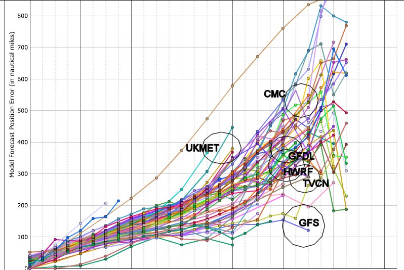 The GFS on 5 day error was roughly 175 miles off whereas the Canadian CMC off by nearly 500 miles @ 5 days. Even the TVCN consensus model which does include the ECMWF data was off by a whopping 260 miles av 5 day error ,intensity wise a range from 20 to 30kts off was common with most reliable models. The National Hurricane Center did a decent job with the exception of continuing to expect a N.W turn which did not happen on several forecast’s and they held steady on a track north of Puerto Rico understandably going with model consensus which none showed a track south of Puerto Rico. If you look at the original NHC advisory with 5 day cone they basically nailed it which is why they preach to look at the whole cone not the just the line down the center. Look where Erika dissipated just S.E of Andros Island compared to the track below and they were not far off even on the timing.
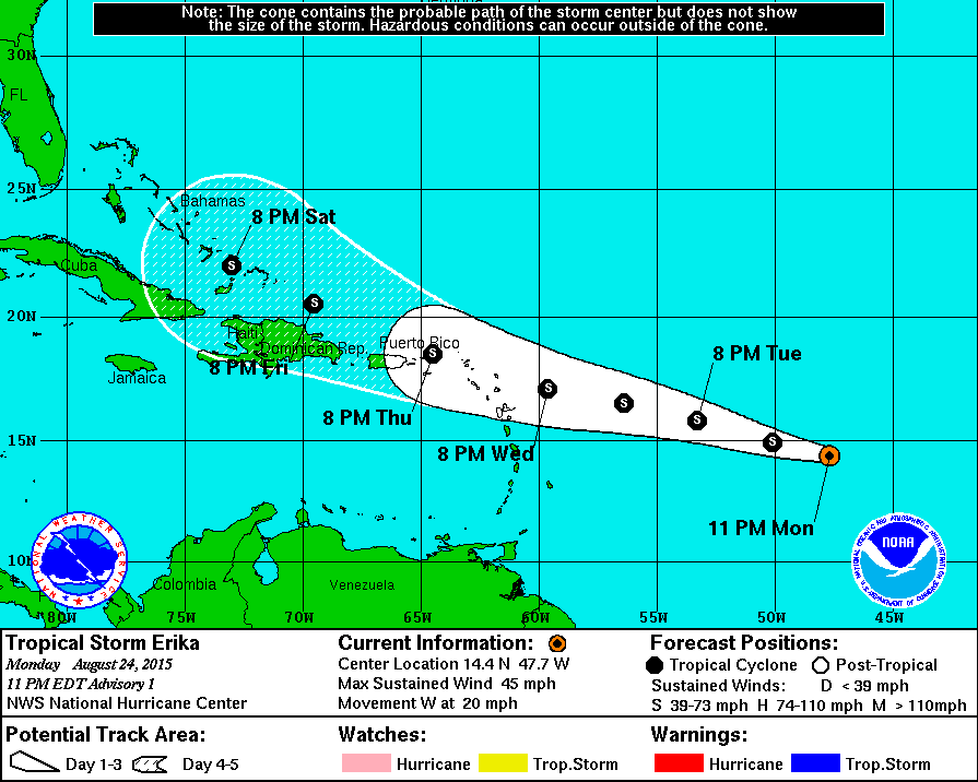 . The sad part of Erika’s legacy is the damage inflicted on the island of Dominica with massive flooding and 20 dead at last report where they were never in the cone or issued warnings perhaps a lesson that your location can be affected even outside the cone.
 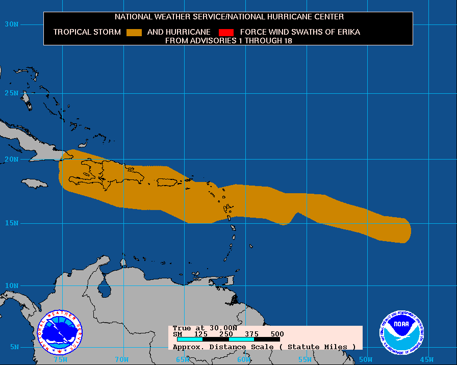 All of the islands and cities in the hurricanecity database from this wind swath will indicate a brush or a hit from tropical storm Erika but none of them were in my top 20 to be impacted in 2015. If Erika makes a comeback perhaps some of my cities in Florida could be hit including #1 area Naples to Pt Charlotte but then again we have a long way to go this hurricane season,always be prepared.
Author: hurcity
Tropical Storm Erika struggling to survive
As of Wednesday evening the 26th Tropical Storm Erika is moving generally west into a wall of upper level wind shear of 20 to 30kts. University of Wisconsin-Madison upper level winds. So will Erika survive at all much less affect the United States? with all the media hype on the U.S potential you would think this was a done deal but not so fast. The mountains of Hispaniola can disrupt the low level inflow into tropical systems and a system does not need to pass directly over the Dominican Republic to come unraveled. Back in 2000 I remember vividly Hurricane Debby moving through the Northern Leeward Islands just like Erika with a cone of error pointing at South Florida. The darling model at that time GFDL had a potential cat 4 moving into South Florida as per the NHC discussion at that time. NHC discussion on Debby from 5AM Aug 23rd. What ended up happening is Debby moved just north of Hispaniola the NHC discussion from 11AM noted
THE LOW-
LEVEL CIRCULATION HAS LIKELY BEEN DISRUPTED BY THE DOWNSLOPE FLOW
OFF THE MOUNTAINS OF HISPANIOLA.
within 24 hrs she would be dead,is the outcome for Erika the same? While I simply will not speculate on any U.S impacts all bets are off unless she survives Hispaniola and if she survives the Bahamas would be next. My #16 pick Great Inagua Bahamas would be in her direct path as a tropical storm if she is further N.E Little San Salvador #15 and potentially after this Great Abaco island #14 for the rest of my picks this year visit Jim’s city predictions so lets see if she survives and then we will talk potential U.S for next week.
Jim Williams on Atlantic hurricane tracking
I have been online talking about hurricanes for over 17 years primarily through my website hurricanecity.com, live and recorded shows, message forums ,chat rooms, social networking sites like twitter and Facebook. In all these years I have never written a blog because I find it easier to verbally express my feelings via my shows or short comments via canetalk.com .
So what prompted me to write a blog? I redesigned hurricanecity.com this year to make it mainly graphic viewing with limited text and opinions. I have also noticed that the popular news websites such as the Washington post, CNN, USA today all produce a page related to the current storm they are not hurricane fanatics like me. You see hurricanecity.com gets indexed well in the search engines but quickly gets pushed out when a storm is approaching land because I do not have a page about the storm and not a lot of text. I am going to give this blog a shot in the hopes that it will get indexed in google and if it does I will do more writing.
This blog will be mainly about the current named storm on the move excluding fish storms turning out to sea. What I have always tried to do since the early days is speak in plain English in simple terms about what I think a hurricane will do and where it will go. I will quote and link to official sources as well as unofficial sources to paint a picture on what the internet community thinks.
Since 2003 I have made predictions around the start of the hurricane season to indicate what cities and islands I feel will be impacted by a named storm. As of now I am 11 of 13 years running by picking at least one of my top five locations to be impacted by a named storm. Already this year my #5 pick was impacted by tropical storm Bill in Matagorda Texas in mid June. I make these calculations using data going back to the late 1800’s using statistics, trends, return rates, analog years etc;. There have been several years where I actually got all five locations correct not to mention many more of my top twenty. Some may say if you have 15 named storms it’s hard to miss but several of my successful years were not busy so it’s not that simple. Go ahead and play pin the tail on the tracking chart with your eyes shut to see how easy it is to pick a point on a map where a named storm will hit.
Over the years I have had NHC directors, NWS staff, emergency management personnel, hurricane researchers go through the database to help tweak the stats or simply comment about the wealth of data. Before the 2014 season I was invited to be part of a panel on hurricane preparedness produced by the keys tourism board. My expertise is not on preparedness but on tracking and predicting so this was not my ideal setting for the conversation. The host Andy Newman from the keys tourism board introduced me as an amateur hurricane hobbyist followed by questions on social networking and public perception about official vs unofficial. I do not think anyone should be muted because I disagree with the assumption that a internet surfer will only use one source . I still believe most people turn on a TV or radio for most information when a hurricane is a threat in combination with the internet . If I read hurricane Joe’s website or blog from Montana writing about a hurricane threat in two weeks for Florida would I stop there and make my plans? of course not I will go to official sources just to make sure.
Do the experts really understand a “hurricane hobbyist” ? While at this meeting I was honored to have discussions with former NHC director and current WPLG hurricane expert Max Mayfield. My first question was how much to you know about hurricanecity? Max responded that he had been to the website but thought it was mainly me saying where a storm would go while a storm is on the move. He is partially correct in the assumption but the maps also include best performing models and cone of error from NHC and usually the featured city is right in the middle of model data. The featured city changes based on the best available data and is flexible compared to my city predictions before the season starts which never change.
Sitting with us before the meeting started were Free press reporter’s Robert Silk and Key West National Weather Service’s Bill South where the conversation turned to enjoying tracking. I said ” when an invest pops on the map (area of potential development given a number) I get excited and think about where it’s going to go” the two nodded in agreement but Max had no expression, this is where the television professional trackers vs amateur/off camera take different paths . Even if a professional wants a hurricane to hit they would never admit it as every TV met knows hurricanes=ratings=more money example Bryan Norcross elevated career due to his coverage of hurricane Andrew in 1992. Hurricane Katrina killed over 1600 people in her wake when Max Mayfield was director of The National Hurricane center ,so I completely understand not being excited about formation potential. After the meeting with the general public I was invited to go fishing with Andy Newman and Max Mayfield where the conversation continued.
Late afternoon tarpon fishing with hurricane legend Max Mayfield in a small vessel in the florida Keys, it does not get any better than this for a hurricane fanatic like myself. The sun begins to set while we continue waiting for the big one wait are we talking Tarpon or Hurricanes? As we wait the conversation went back and forth about my challenges with hurricanecity such as development,servers,hacking,court actions,editing techniques such as doing it all right from a smart phone. With all that said I stated it is an out of pocket hobby with minimal fan fare compared to what others say about their product’s. When Max brought up the big one my mind keeps thinking Hurricane Andrew where I said “yes I was here then” when he said “no I am talking about hurricane Katrina”. This was the most challenging of his career and is thinking about writing a book on it but some of this stuff may just stay in the boat. The subject again turned to my predictions where Max said “I see you have Key Largo #12 on your list this year” I was honored to know he was keeping track just at that moment FISH ON . My drag is taking off followed by a large Tarpon jumping high into the air I pull back on the rod but it got away,the heart pounding excitement if just for a minute alone was worth the trip. So back to hurricane talk Max and Andy both reflect on past hurricanes right where we were sitting such as the 1935 Labor Day Hurricane as the sun sets. Soon after Max has a large Tarpon on line he sets & reels in but the same thing happens as the tarpon pops off line after jumping, I was ready with camera to film the action. Video taping Max Mayfield reeling in a huge Tarpon would have been one for the social networking ages. In the dark before heading back both asked about my paving business which pays my bills and after explaining my process wondered how I could do hurricanecity at all.
Hurricane tracking to me is a break from the daily stress of running a business and I assume for other hurricane hobbyist’s an escape to try to be one with nature and I am sure your families understand right? There is room at the table for everyone because every voice creates awareness of hurricanes from a landfall point on a map to a storm chaser or to a useless 2 week model projection,to all you hobbyist’s happy tracking and to all you pros keep up your great work!