Ranking this years big three

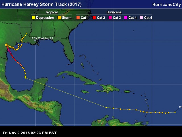
What a hurricane season it has been with three major hurricanes hitting land in the Atlantic basin starting with Harvey then Irma and finishing with Maria all within 27 days during the height of the season. Each Hurricane was devastating to the communities affected and it is extremely difficult to rank these three. Each impacted large areas,killed many and crippled infrastructures. Now what does rank mean? I will rank these three hurricanes based on impacts on human lives. I will give descriptions of each of the three hurricanes in order in which they developed (stats may not be exact as these are ongoing disasters). It all started with a tropical depression east of the Windward Islands on August 17th and like it’s predecessors early in the season struggled to survive due to unfavorable conditions aloft. The system weakened to an open wave in the central Caribbean, traveled west crossing the Yucatan Peninsula in the western Caribbean where if finally found a favorable position with low shear and very warm sea surface temperatures. On August 24th it developed into Tropical Storm Harvey in the Bay of Campeche and at this point the 2017 Atlantic Hurricane Season took a turn for the worst. In less than nine hours Harvey would become a hurricane setting the stage for several powerful hurricanes in less than a month.
Hurricane Harvey rapidly intensified to 130 mph as it made it’s way onshore just north Of Corpus Christi,Texas late on August 25th. The wind damage was extensive in Rockport and surrounding communities in Texas but this was just the beginning of what would be a deadly flooding situation in the Houston area over to Port Arthur,TX and western Louisiana. For the next five days Harvey would force nearly 40,000 residents from their homes after dumping over 50″ of rain in some locations as Harvey flooded over 100,000 homes. Costliest of big three est 180 Billion in damage

Track of Hurricane Harvey

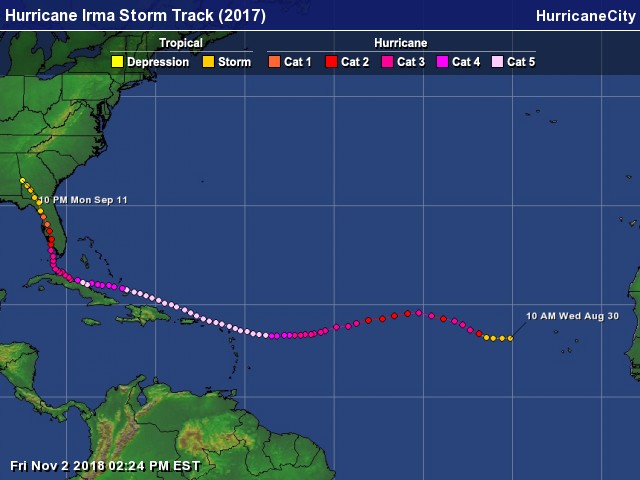
Less than a week later Tropical Storm Irma forms west of the Cabo Verde Islands and once again becomes a hurricane in less than 24 hrs. On September 6th the eye of Hurricane Irma passed over the tiny island of Barbuda with 185mph winds causing complete devastation and leaving the island uninhabitable. Next up would be the islands of St Martin/Sint Maarten , Anguilla, Saint Barthelemy , St. Kitts and Nevis , St. Eustatius all with extremely heavy damage by the same 185mph winds. Next would be the Virgin Islands of St Thomas and St John 185mph direct hit same results with extreme damage. Irma would pass just north of Puerto Rico causing quite a bit of damage and left residents feeling like they dodged a bullet ,little did they know what was coming next. Hurricane Irma weakened slightly to 165mph while passing just north of Great Inagua Bahamas causing heavy damage but sparing the island of Irma’s worst winds. On September 9th Hurricane Irma raked 250 miles of the north coast of Cuba entering west of Nuevitas regaining cat 5 status and exiting well east of Havana with 120mph winds taking ten lives before turning towards the Florida Keys. On September 10th Hurricane Irma hit the lower keys with 130mph winds while turning NNW causing very heavy damage from Big Pine Key to Islamorada est one in three structures heavily damaged. That same evening of Sept 10th Irma made it’s final landfall in Naples with 110mph winds causing heavy damage to weaker structures such as mobile homes. Irma continued weakening while moving up Florida’s west coast causing hurricane force wind gust’s over nearly the entire peninsula causing the largest power outages in Florida’s history affecting over 6 million customers . Up in Georgia Tropical Storm Irma caused trees to topple and left of 1 Million without power. In South Carolina coastal flooding in some areas was worse than reported from Hurricane Matthew in 2016. Most intense winds of big three 185 mph in Barbuda,St Martin/Maarten,Anguilla,Saint Barthelemy,St. Kitts and Nevis , St. Eustatius,St John,St Thomas.

Hurricane Irma track

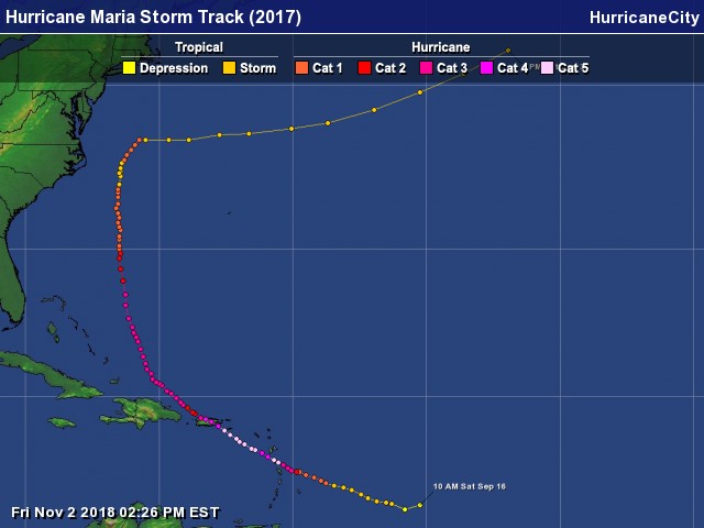
Once again less than a week later on September 16th a tropical depression formed east of the Lesser Antilles. Once again in less than 24 hrs hurricane Maria is born and within 48 hrs Maria becomes major. On the evening of September 18th Hurricane Maria hits the tiny island nation of Dominica with 160 mph winds a category five. The island was devastated and when all finished Maria left 27 dead. Next up would be the island of St Croix where Hurricane Maria was at it’s strongest with 175mph winds while passing just south. The damage here was reported as worse than what happened in 1989s Hurricane Hugo leaving the entire island without power. Next up would be Puerto Rico as Hurricane Maria approached from the S.E on Sept 20th with 155 mph winds and crossing the entire island as a major hurricane. The entire island was hit extremely hard knocking out the entire power structure and killing 51 although those numbers are in dispute ,some say up to 500 were killed. As of this post this outage has caused a loss of 2.5 billion hours of electricity supply making it the largest black out in U.S History. Lowest pressure of the big three upon passage St Croix 910 MB.

Hurricane Maria track

So now that we have a general idea of what happened in these affected areas let me state that there are not enough words to adequately describe how much these three hurricanes impacted peoples lives. The common sense answer would be all three are equal in how bad they were, but for arguments sake I will take a shot at which was the worst.

Big three styatistics

Stats above based on latest news reports from numerous news and government sources.


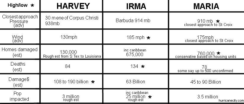
#1 worst Even though Hurricane Irma scored the most highs amongst the three according to the chart above I cannot escape the thought of having the majority of the power grid off line for nearly 2 months as is the case in Puerto Rico from Hurricane Maria. Dominica and St Croix also have gone for an extended period of time with limited electricty or potable water. All three of these areas will be lucky if the vast majority of residents have all services back up by Christmas. Even cell connectivity is limited in many areas,talk about frustration. Based on between 700,000 & 800,000 housing units not having basic needs makes Hurricane Maria the worst.


2nd worst Maria was known mainly for wind destruction but Hurricane Harvey was known more for flooding in so many areas it’s hard to imagine. Harvey was also a wind machine at landfall in Texas destroying many structures. Harvey took 84 lives mainly due to flooding after it lost hurricane status. Up to 15,500 homes were destroyed with estimates of over 200,000 damaged in the entire impacted area from South Texas to Louisiana. Even though less people were impacted by Hurricane Harvey than Irma the amount of time people have had to deal with re construction and mental anguish puts Hurricane harvey at #2.


3rd worst Even though Hurricane Irma impacted more people probably than the other two combined you can only look at the amount of time the majority of the over 25 million had utilities. The majority of outages in Florida were restored within 1 week and the total 8.7 million that lost power in the S.E United States was 99% restored within 14 days. There were some outages with cell towers but within a week most of that was restored. There was heavy damage in the Florida Keys but they are far better off than the Maria stricken areas. Unfortunately areas of Cuba,Virgin Islands (also impacted by Maria) and the N.E Lesser Antilles especially the island of Barbuda may take years to recover but population wise much less than Maria. Had the peninsula of Florida been hit by the same Irma that hit Cuba and the Lesser Antilles it probably would have been #1.

City predictions for the 2017 Atlantic hurricane season

Lower number of named storms, new forecast techniques added & cities more spread out than last year.

According to model data it appears we will have weak elnino conditions in the East Pacific at the height of or later in the Atlantic hurricane season. So what does this mean? a chance of increased wind shear across parts of the Atlantic basin approaching the height of the season Sept 10th. Tropical systems like to develop when calmer conditions are present in the upper levels of the atmosphere. Most development in the Atlantic occurs between August and the end of October when conditions are ripe but it could be different this year. As of just before this post the water temps in the enso region have somewhat cooled but this could have been caused by a temporary shift in trade winds and I still think deep into the hurricane season these SSTs will increase to near or at weak Elnino conditions.


International research institute for climate and society

For an elnino event to be established there needs to be a three month period of 0.5 degrees or greater SST’s in the nino 3.4 region and most models show this happening. This is a strong feature in my eight criteria put into my city predictions based on how many named storms there could end up being. This year I am calling for 12 to 14 named storms, last year I was calling for 14 to 16 named storms and we ended up with 15 named storms in the basin. As a result there will be practically a whole new set of cities chosen to be impacted by a named storm for this year with a couple of leftovers from last season. As for elnino comparisons I researched past seasons with similar SST temperatures in the East Pacific and was able to subjectively choose seven past years that come close to lining up with what the models are projecting listed below.
Elnino Analog years
Climate Prediction Center

METHODOLOGY

So now that you know my main factors for making my city predictions I need to make it clear that one or more of my top 20 may not meet the criteria above. There are several other methods used in arriving at my final list and sometimes these change from year to year depending on each methods success. This years list of methods not necessarily listed in the order of importance below.

  • 12 to 14 named storms finding similar seasons since 1990, were any of my top 20 locations affected in seasons like this? most of top 20 decided based on this criteria,leaning lower towards 12. As of mid May wind shear is screaming across the western Atlantic basin so I think we could get off to a slow start.
  • ENSO (Elnino Southern Oscillation) Comparing past seasons East Pacific sea surface temperatures to what model expectations show for hurricane season. What cities in my top 20 were impacted during these analog years.
  • Cities most due or overdue for all named storms based on av return rates from 1871.
  • Cities most due or overdue for hurricanes only (74 mph & up) av since 1871.
  • Average number of storms when these top 20 locations were directly hit by a hurricane since 1900.
  • NAO North Atlantic Oscillation based on expected positive stage causing higher trade winds & cooler north Atlantic SST’s. Since 1990 what cities were affected in a positive phase based on April stats.
  • Trends Criteria a similar event happening 3 or more times since 1871,(example) A hurricane hit a particular city in 2016 did the city get hit the following year in a similar way?
  • Were any of these top 20 in the top 20 last year? what ranking & for what reason.

Introducing the NAO “North Atlantic Oscillation” into my city predictions. For the first 12 years my city predictions were based on mainly return rates & statistical averages. My track record during this period was very good considering I averaged 2 or more of my top 5 cities impacted each season or 10 for 12 with the other two seasons having one/zero cities impacted out of a potential 152. Since introducing ENSO I have zero in 2014 and one in 2015 of my top 5 and just under 50% of the remaining top 20,so adding another factor such as the NAO may make things worse. Needless to say I am not pleased about adding these predictors as the statistical rates have served the process just fine. Continued questions from academia & pros about past statistics not being reliable enough has forced me in to uncharted territory but may be short lived if it does not add value. Using a starting point of 1990 I see if any of my top 20 were impacted in a plus year.

Using the chart below each location is calculated and the highest amount in each category wins (highlighted in yellow) there are no tie breakers so more than one may be highlighted in each category. My top five picks are the winners with the most yellow boxes, in tie situations weight is put on the significance of each criteria. Fourteen of the locations had no yellow boxes but the closer numbers to the top five locations get the nod in the positioning. Due to the uncertainty of the NAO criteria it is given very low value in positioning.


  • #1) Sable Island, Nova Scotia
  • #2) Gulf Shores, Alabama
  • #3) Marathon, Florida
  • #4) Isle Of Youth, Cuba
  • #5) Cayman Islands
  • #6) Long Island, New York
  • #7) Halifax, Nova Scotia
  • #8) Antigua
  • #9) Dominica
  • #10) Cape May, New Jersey
  • #11) Montego Bay, Jamaica
  • #12) Port O’Connor, Texas
  • #13) Key Largo, Florida
  • #14) Ponce, Puerto Rico
  • #15) Sarasota, Florida
  • #16) Cap Haitien, Haiti
  • #17) Providence, Rhode Island(entire state)
  • #18) Santo Domingo, Dominican Republic
  • #19) Kenedy, Texas
  • #20) Corpus Christi, Texas

  • Each & every year there will be one or more locations affected that I did not pick. My past track record would indicate if you are in my top 20 you statistically have an increased chance for a named storm. If you are in the top five there is a pretty good chance 2 or more locations will be impacted. Last year for example 9 of 20 were impacted by a named storm, not bad considering I am plucking from 152 locations across the Atlantic basin. If you were told you had a 50% chance of being struck by a vehicle at a certain location you would look not just twice maybe three or four times. There is no harm in preparing for hurricane season regardless of your city on this list or not better safe than sorry. It is advisable to know your evacuation & flood zones, know where you will evacuate to and how you will get there, do they take pets?. As time goes by I will be adding my past years predictions notes and verification of what worked or did not work since 2003. This information will be added to my predictions page at Jim’s Predictions where you will also find maps & videos of my predictions. Thank you for your time and good luck this hurricane season.

    global warming and land falling hurricanes

    By Jim Williams 2/21/17 ……Climate change or as I like to call it “Global warming” is trending more ominous for the future of our earth. The sea level rise threat is growing and we are seeing weather extremes on the increase world wide. When it comes to hurricanes there are differing opinions from increased wind shear keeping storms weaker in contrast to storms being bigger and stronger. According to Dr. Ryan N. Maue of Weatherbell Global accumulated cyclone energy values were up just slightly from the sum average in 2016 and the same goes for the Atlantic Basin. global ace values

    The next question is are we going to see more hurricanes as a result of global warming? The National Hurricane Center’s (HURDAT2) database over the years has actually added named storms that were previously unknown mostly out over the open waters. Despite the additions it does appear that the over all count is slightly increasing especially majors in the Atlantic basin especially since 1995. Atlantic basin storm count

    Probably the most difficult question is when did global warming start? CO2 as well as increased Methane have been on the rise since according to historic ice core samples but have really taken off since the 1950s. A really handy tool to use can be found on NOAA’s National centers for environmental information where you can choose your state or region to see how temperatures have increased since 1895. After choosing the Atlantic coastal states one by one I have come to the conclusion that temps have steadily increased since 1975 using the month of most hurricane activity in the basin September. The graph below shows both land & sea temps in September globally on the increase so how will the tropics respond in the Atlantic basin?

    The most important question is how many named storms will make landfall impacting lives of some people who otherwise could care less about global warming. This is where I like to take the statistics a step further by taking my 152 locations in the HC city Database down to the city level or looking through a microscope. For arguments sake I will use the year 1975 as the (start) of global warming in reference to examining land falling systems in the Atlantic basin. I am using six spread out locations vulnerable to hurricanes to make my point. Data includes all tropical storms, Hurricanes brushes and hits (inc extrop). Starting with Galveston,Texas from 1871 to 1974 had an average return rate of every 2.73 years for a named storm. From 1975 to 2016 unchanged at 2.73.


    New Orleans has seen a slight increase in the frequency of named storms 1871 to 1974 at every 2.31 years compared to 1975 through 2016 at 2.27 years between storms.

    Miami has had the opposite happen more named storms from 1871 to 1974 return rate of every 1.79 years compared to 1975 to 2016 at every 2.73 years.

    Using the most affected area in the Atlantic basin Cape Hatteras also shows a slight decrease in brushes & hits from named storms before 1975 at 1.30 years to a greater gap between storms since 1975 of 1.52 years.

    Using the most populated center in the U.S NYC including all of Long Island from 1871 to 1974 had a return rate of every 2.53 years compared to 1974 through 2016 every 3.41 years.

    Lets examine St Johns ,Newfoundland in the far northern Atlantic basin. Here a dramatic increase going from a return rate of every 3.85 before 1974 and from 1975 to 2016 an amazing accelerating return rate of every 1.95 includes extratropical systems.

    Just to make sure these numbers are correct I decided to check on the area furthest south & east of the U.S vulnerable to named storms. The island of Saint Martin too has seen a decrease in named storms since 1975 of every 3.41 years compared to 2.60 years prior to 1975. I even decided to calculate the numbers starting at 1995 taking into consideration the recent upward trend in activity of the Atlantic basin and the numbers show a much quicker return rate for Cape Hatteras and Long Island. A conclusion to my findings indicate an increase of tropical activity from 30 degrees north since 1995 with a decrease in activity further south. Why are the northern locations being hit more frequently while south locations are being affected less? I will leave this to the highly educated experts that can explain more frequent landfalls further north. Maybe this is just a recent trend but regardless of these numbers global warming has caused an increase in sea level rise and with a trend of more intense hurricanes puts all of these areas in grave danger from storm surge……….Jim WIlliams